
In the mornings, we load the car in the same fashion. He does the trunk, I do the inside of the car, making sure there is ice in the cooler for water bottles. He does the driving. I navigate with the guide book and Sparky's iPhone 4G (We would have been lost without that phone, literally. Who needs gps?). I take the pictures while he is driving. It's working great. A well oiled team.
I have so many beautiful pictures of the rocks and scenes but I do not want to bore you with lots of scenery pictures so I'm trying to limit how many I upload.
We decided to leave the Route 66 road today and take a side trip up to Santa Fe. Santa Fe is about 60 miles due north of Albuquerque. It is a beautiful city and we could not have ordered a more perfect day. Absolutely gorgeous. We only spent a couple hours there. I would love to go back sometime. There's so much to see and do in the Santa Fe/Albuquerque area. But not for this trip.

This is the view of Santa Fe as we approached on the interstate.
 Love the adobe style houses. That's pretty much all we saw there.
 Guess what? We thought we were veering off the mother road but here it is. We knew that there was a Santa Fe road option that went up there but we did not expect to find it. We shopped for a couple of hours and then headed back to Route 66 via Albuquerque (I"m getting tired of typing that word. It doesn't flow very well. ;-))

As we left Albuquerque, this is the view that we saw. There's no way that these pictures can do it justice. It was like being in the bottom of a huge bowl. Unbelievable.
 Sparky said this looked like a Mini-me version of the Grand Canyon. (Please excuse my reflection in the window of the car. It was too hot to roll down the window when taking these pictures)
 We were driving the road and I saw this really cool rock so I took a picture of it. As we went on down the road, I read in the guide book that we would pass the "Owl Rock" and then the "Dead Man's Curve". I knew when we reached Dead Man's Curve but was sad that I missed the Owl Rock. Imagine my surprise when I looked at my pictures tonight and there was a picture of Owl Rock. Very cool.
 Route 66 runs right next to a couple of pueblos. The book said that we should be very careful about not going onto pueblo land, and that we were to treat the land with respect. This was the first one we passed, the Laguna Pueblo.
 You can't see the houses very well in this picture but it is some of the houses that the people live in on the pueblo.
 This is what I supposed to be a water tower from for the pueblo.

These two pictures fascinated me. They were on opposite sides of the road but well off the road. If you will notice the ridge of rocks that make up the edge on both sides. The rocks are lined up like building blocks. They are almost perfectly even and aligned. I commented to Sparky about this. I assumed that they had been cut and stacked that way by man to form a ridge. He said that is the way they were naturally. The perfectness and straightness of the "building blocks" was no accident. It was an intelligent design.

I don't know about you but I think I'd like to visit that church.

I took this picture because of the little house that is in ruins in the left center of the picture. It made me wonder how long it had been there, who once lived in it and what kind of life they had.

 These two pictures are of some lava fields that we passed. Question: if these are lava fields, where did the lava come from? Doesn't lava have to come from volcanoes? I don't recall hearing anything about volcanoes in New Mexico.
 Grants, New Mexico: where we ended up tonight. Tomorrow we cross the Continental Divide and we will sleep in a wigwam. More to come.


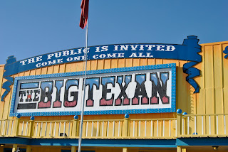 When in Amarillo, it is a requirement to eat at The Big Texan. They have a 72 oz. steak dinner that if you can eat the whole thing in 60 minutes, you get it free. If you can't do it, it costs $72.00. Beleive it or not people do it all the time. Someone did it this past Saturday. WOW! That's not a steak. That's a roast.